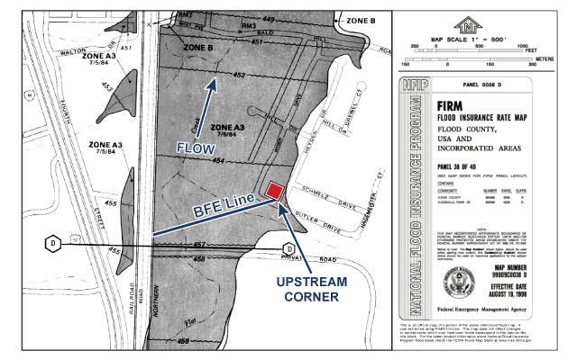
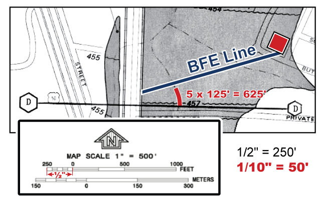
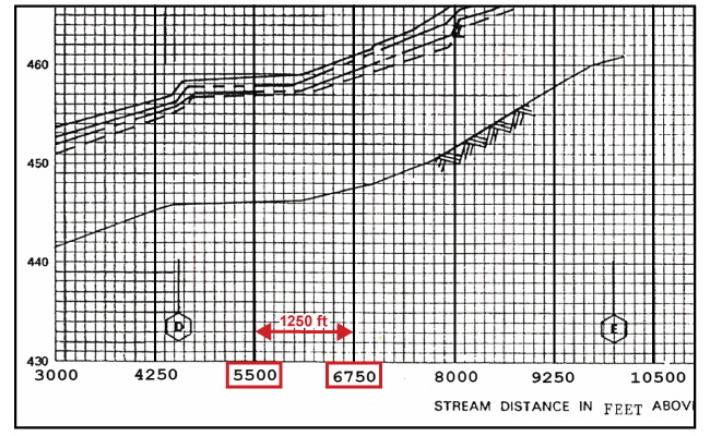
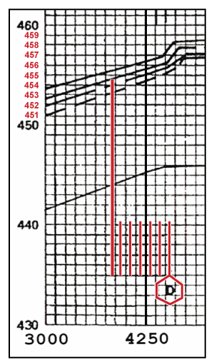
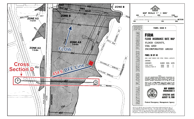
Step 1 of 7: Find the location of the property and structure on the FIRM. In this example, first find the general location (corner of Heyden Dr and Butler Drive). Next determine direction of flow by using rounded BFE’s on map. Finally, locate the exact point representing the upstream corner of the structure (25 feet from center of Butler Road, 35 feet from center of Heyden Dr).Step 2 of 7: Draw a site specific “BFE line” perpendicular to the flow of the stream. Starting at the upstream corner of the structure, draw a straight line towards the main waterway and perpendicular to the centerline. In this example the BFE line must be drawn at an angle so that it is perpendicular (forms a +) when it crosses the centerline of Flat Creek.Step 3 of 7: Identify the FIRM/FIS common element nearest to the intersection of the BFE line and Centerline. Which of these three common elements; Bald Hill Road Crossing, Cross Section D, or Private Road Crossing is the closest to the site BFE line where it crosses the centerline of Flat Creek?Step 3 of 7 Continued: Cross Section D is the closest common element. Measuring to the closest common element reduces the chances of making a measuring error. Note: Cross Sections are preferred common element due to possible variation in measurements caused by width of bridges. If using a bridge, actual ground measurements may be necessary for accuracy.Step 4 of 7: Measure the distance from closest common element to the property BFE line. This measurement is made along the centerline of the stream, not using a straight line directly between cross sections. Therefore you must measure along any meanders the stream contains. This can be challenging.Step 4 Continued: Choose a straight increment measurement that roughly represents the curved portions of the stream line. This example uses a quarter inch which is equal to 125 ft. on the map scale.Step 4 Continued: Start measuring from the Cross Section D (the nearest common element). Continue this process along the stream line until no more quarter inches can be measured without extending past the Site BFE line. (5 X 125 ft. = 625 ft.)Step 4 Continued: Now measure the remaining length of stream from you last increment to the site BFE line to determine the remaining distance. In this example the final measurement is equal to two segments on the 0 - 250 scale that is subdivided into five 50 ft. segments. (2 X 50 ft. = 100 ft.)Step 5 of 7: Add up the measurements from the FIRM to use with the FIS Flood Profile. In this example, all of the FIRM measurements totaled 725 ft. downstream from Cross Section D. ( (5 X 125 ft. = 625 ft.) + (2 X 50 ft. = 100 ft.) = 725 ft.). The 725 feet measurement now needs to be transferred to the FIS Flood Profile.Step 5 Continued: First determine the profile’s “square” measurement. Begin by finding the distance that the major grid line interval represents. In this example, the major grid distance is 1,250 ft. (6,750 ft. – 5,500 ft. = 1,250 ft.).Step 5 Continued: Next, count how many squares there are in a major grid interval. In this example there are 10. Divide the major grid distance by the number of squares. (1,250 ft. / 10 = 125 ft. per square). Note: There are always 10 small boxes within the major grid intervals.Step 5 Continued: Now you need to calculate how many small boxes will equal 725 ft. Divide the measured distance from the FIRM (725 ft.) by 125 ft., the distance represented by one small box. (725 ft. / 125 ft. per box = 5.8 boxes.) On the Flood Profile, count 5.8 boxes downstream (going left) from Cross Section “D”.Step 6 of 7: Identify the 1% Flood Profile for the property. After measuring the distance downstream from Cross Section D on the Flood Profile, extend a vertical line up until it intersects the 1% Flood Profile line. Be sure to check the profile legend and stop at the correct water surface profile line since up to 5 profile lines may be shown in newer FIS.Step 7 of 7: Identify the BFE for the property. Extend a straight line from the point where the vertical line meets the 1% flood profile line to the nearest vertical axis. In this example, each square on the elevation axis equals one foot. The line intersects a little above the middle of a box between 454 and 455. BFE = 454.6. This is the correct BFE for this site using the FIS accurate to the tenth of a foot as required by the NFIP. Note that this is more than two feet lower than the rounded BFE shown on the FIRM directly below Cross Section D.(Step 7 Continued) BFE = 454.6 is the correct regulatory BFE for this site using the FIS, as required by the NFIP. Note that this BFE is more than two feet lower than the rounded BFE for Cross Section D of 457 ft. (457 ft. - 454.6 ft. = 2.4 ft.) | 
