Lesson 4 Objectives

At the conclusion of this lesson, for individual map panels, you will be able to:

  • Recognize elements found on most individual Map Panels
  • Recognize elements found on some Flood Boundary and Floodway Maps (FBFMs) or Flood Insurance Rate Maps (FIRMs)
  • Recognize elements found only on Countywide flood map Panels
How to Read a Flood Map Panel (Slideshow)

When a flood map cannot be presented on one page, it is produced on several pages known as Panels. Flood Map Panels depict the flood hazards in different parts of a community.

Scroll down to see slideshow captions.

Note: Floodways are not calculated in all riverine flood studies.
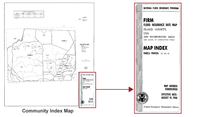
Community Index Map
Note: Flood Hazard Boundary Maps (FHBMs) will not have floodways.
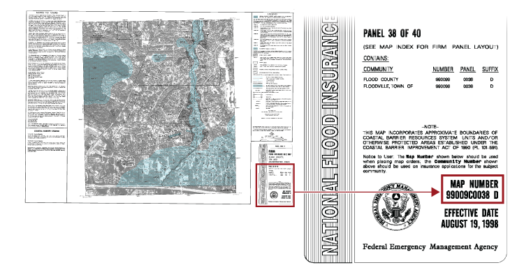
On the Community Index Map, Panel Number 99009C0038D is highlighted and magnified.
Note: On pre-1986 FIRM/Flood Boundary and Floodway Maps (FBFMs) the floodway will be shown on the FBFM panel.
The Map Panel with Map Number 99009C0038 D identified on the Map Index
Elements that May Be Found on All Panels

There are additional elements that may be found on nearly all flood map Panels. Newer maps may not include all of these elements:

  • Floodplain Boundaries
  • Hazard Area Designation
  • Base Flood Elevation
  • Flood Zone Division Line
  • Flood Insurance Risk Zone Designations
  • North Arrow
  • Stream Lines
  • Coastal Barrier Symbol
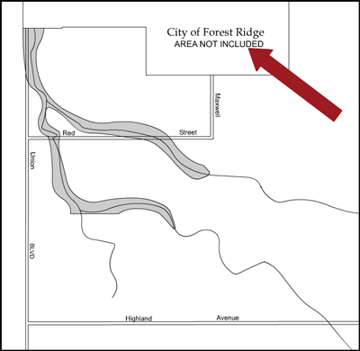
  • Area Not Included Label
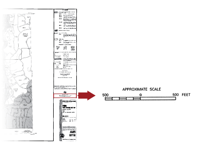
  • Map Scale
  • Panel Number
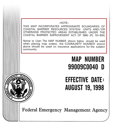
  • Notes to User
  • Elevation Reference Marks (ERMs)

Each element will be discussed in further detail on the following screens.

Elements that May Be Found on All Panels: Floodplain Boundaries

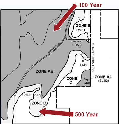
Floodplain boundaries show the 1-percent (100 year) annual chance and 0.2-percent (500 year) annual chance floodplains.

A magnified section of the map panel with arrows pointing to the floodplain boundaries
Elements that May Be Found on All Panels: Hazard Area Designation

The shade and pattern indicate areas of different flood hazard and the flood zone.

*Note - see map legend for listing of all flood map hazard area shades and patterns with appropriate zone designation.

(on newer maps the lighter gray Zone B area below indicating the 0.2% (500 year) floodplain area and the white Zone C area will both be listed as Zone X)

Flood map - dark tint indicating 100 year flood hazard area and lighter tint indicating 500 year flood hazard area
Elements that May Be Found on All Panels: Rounded Base Flood Elevation (BFE)

For detailed study Special Flood Hazard Areas (SFHAs) this label indicates the water surface elevation of the base flood, rounded to the nearest foot, in relation to a standard set of geographic data.

A wavy line is used to indicate when this rounded base flood elevation varies along a watercourse (Typically Riverine AE zones).

When the rounded base flood elevation is uniform across a large area, a BFE label below the zone label is used (Typically Ponding AH, Lacustrine (Lake) AE, and Coastal AE and VE zones).

Remember, you must refer to the Flood Insurance Study Profile to get the actual BFE for floodplain management and flood insurance purposes.

Flood map segment with arrows pointing at several base flood elevations, 105, 106, 107, 108, 108, 108 and 110 BFD are noted at the cross sections.
Elements that May Be Found on All Panels: Flood Zone Division Line

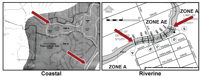
This white line separates Special Flood Hazard Areas with different zone designations. It is also used to separate Special Flood Hazard Areas with differing Base Flood Elevations in coastal hazard areas.

*Flood Zone Division Line is also used to indicate the "Limit of Detailed Study" which is the dividing line between Zone AE and Zone A.

This line may also be called the Zone Break Line or Zone Boundary Line.

Section of FIRM with arrows pointing at Coastal zone division lines. (Zone designations not legible) Section of FIRM with arrows pointing at Riverine Zone division lines between Zone A and Zone AE.
Elements that May Be Found on All Panels: Flood Insurance Risk Zone Designations – SFHA Zones A and V

The zone designations indicate the magnitude of the flood hazard in specific areas of a community.

A Special Flood Hazard Area (SFHA) is defined as the area that will be inundated by the flood event having a 1-percent chance of being equaled or exceeded in any given year.

SFHAs are labeled as:

  • Zone A
  • Zone AE and Zones A1-30
  • Zone AO
  • Zone AH
  • Zone AR, AR/A1-30, AR/AE, AR/AH, AR/AO, and AR/A
  • Zone A99

SFHAs subject to coastal high hazard flooding are designated V Zones:

  • Zone V
  • Zone VE and Zones V1-30
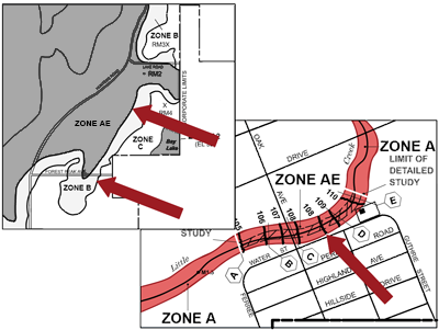
Flood map with ZONE A, ZONE AE, and ZONE A highighted
Elements that May Be Found on All Panels: Flood Insurance Risk Zone Designations – Moderate & Minimal Flood Areas

Moderate Flood Areas

Moderate flood hazard areas, labeled Zone B or in newer FIRMs as Zone X (shaded) are also shown on the FIRM, and are the areas between the limits of the base flood and the 0.2-percent-annual-chance (or 500-year) flood.

Minimal Flood Areas

The areas of minimal flood hazard, which are the areas outside the SFHA and higher than the elevation of the 0.2-percent-annual-chance flood, are labeled Zone C or in newer FIRMs as Zone X (unshaded)

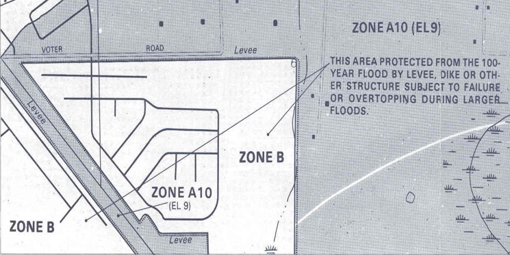
Zone D: Area of undetermined but possible flood hazard.

The image is a portion of a community's Flood Insurance Rate Map. Zone B. Arrows pointing to Zone B are labeled "This area protected from the 100-year flood by levee, dike or other structure subject to failure or overtopping during larger floods.
Elements that May Be Found on All Panels: North Arrow

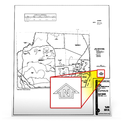
This arrow orients the flood map to north.

Note: On older map sets the north arrow may not be oriented to the top of the map panel.

flood map with north arrow highlighted and magnified.
Elements that May Be Found on All Panels: Stream Line

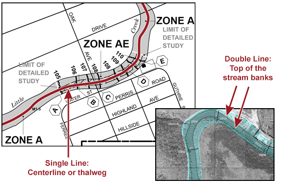
Stream lines identify the location of a watercourse.

Narrower streams are usually shown by a single line, representing the approximate location of the lowest elevation of the stream (centerline or thalweg).

Wider streams are shown by double lines, representing the location of the top of the stream banks.

Flood Map element stream line. Single line: Centerline or thalweg. Double Line: Top of the stream banks
Elements that May Be Found on All Panels: Coastal Barrier Symbol

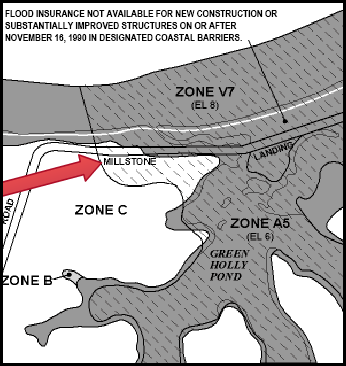
These symbols identify coastal areas in the Coastal Barrier Resources System (CBRS) and Otherwise Protected Areas (OPAs).

CBRS zones are designated by the US Fish and Wildlife Service. No new flood insurance coverage may be provided after specified dates for new or substantially improved structures on any Coastal Flood Hazard Area in the CBRS.

OPAs are a category of coastal barriers within the CBRS. OPAs are undeveloped coastal areas established under Federal, State, or local law, or held by a qualified organization, primarily for wildlife refuge, sanctuary, recreational, for natural resource conservation purposes. Flood insurance is restricted in OPAs, though OPAs may receive other forms of Federal assistance. OPAs are identified on FEMA FIRMs.

Note: New FIRM panels will no longer include designated CBRS zones. However the National Flood Hazard Layer (NFHL) Viewer displays this information.

Arrow pointing to designated coastal area.  Flood insurance not avaialbe for new construction or substantially improved structures on or after November 16, 1990 in designated coastal barriers. Inside coastal barrier Zone V7 (EL 8') Zone A5 (EL 6) Green Holly Pond
Elements that May Be Found on All Panels: Area Not Included Label

This label identifies areas that are in the Panel area but are not in the jurisdiction of that community; thus, no flood hazard information is shown in that area

Arrow pointing to note on Flood map, Note states City of Forest Ridge AREA NOT INCLUDED
Elements that May Be Found on All Panels: Map Scale

This allows you to relate distances measured on the flood map to actual distances on the ground. The scale shown on a Panel applies only to that Panel. Scale ratios can vary from panel to panel. The most commonly used scales on flood maps are one inch on the map equals 500, 1000, or 2000 feet on the ground.

Map scale highlighted - Approximate scale  500 (5 units) 0 (Single unit = to 5 units) 500
Elements that May Be Found on All Panels: Panel Number

This number distinguishes each Panel from others in the same community; each page is given a unique Panel number. On FHBM, the Panel number is a two-digit number. On FBFM/FIRM the Panel number is a four-digit number.

Panel Number/Community – Panel Number/Map Number

Different types of numbers appear on flood map title boxes prepared in different formats. Each type of number identifies the Panel that covers an indicated portion of the community.

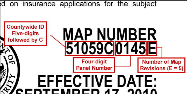
On FIRM title boxes, the first set of numbers identifies the community or countywide ID number. The second set of numbers identifies the Panel number. The trailing letter after the panel number corresponds to the number of map revisions.

On Indexes, the second set of numbers corresponds to the range of printed Panels.

The entire 11-digit code for each Panel is required to identify a Map Panel. The Panel number includes the 6-digit CID or the 5 digit CWID followed by the letter "C" and the Panel number, as well as a letter suffix (which indicates the map revision number).
Map FormatType of NumberPanel ExampleIndex Example
Flood Hazard Boundary Map (FHBM)Panel NumberMAP 04MAP 01 -04
FIRM/FBFM for Individual CommunityCommunity-Panel NumberCOMMUNITY-PANEL NUMBER 480662 0001E COMMUNITY-PANEL NUMBERS 480662 0001- 0020
Countywide FIRMCountywide-Panel NumberCOUNTYWIDE-PANEL NUMBER 48029C 0308D COUNTYWIDE-PANEL NUMBERS 48029C 0001-0350
Example Countywide Panel Number

In this FIRM title boxes, the first set of numbers is the countywide ID number. The second set of numbers identifies the Panel number. The trailing letter is the number of map revisions.

Map Number 51059C0145E. Countywide ID Five-digits followed by C - 51059C. Four digit Panel Number - 0145. Number of Map Revisions (E equals 5)
Elements that May Be Found on All Panels: Notes to User

These notes provide additional information to clarify zone designations or special notes on the use of the flood map.

Other examples of Notes to User:

  • Information on Horizontal and Vertical Datum.
  • Certain areas not in the special flood hazard areas (Zone A and V) may be protected by flood control structures.
  • This map is for flood insurance purposes only; it does not necessarily show all areas subject to flooding in the community or all planimetric features outside special flood hazard areas.
  • For adjoining map panels, see separately printed Index To Map Panels.

Click Datum to open the definition in a new widow.

Note. This map incorporates approximate boundaries of coastal barrier resources system units and/or otherwise protected areas established under the Coastal Barrier Imporvement Acto of 1990 (PL 101-591) Notice to User: Ths Map Number show below should be used whenplacing map orders, the Community Number show above  should be used on insurance applications for the subjet community. Map Niumber 99009C0040 D Effective date August 19, 1998
Elements that May Be Found on All Panels: Elevation Reference Marks (Slideshow)

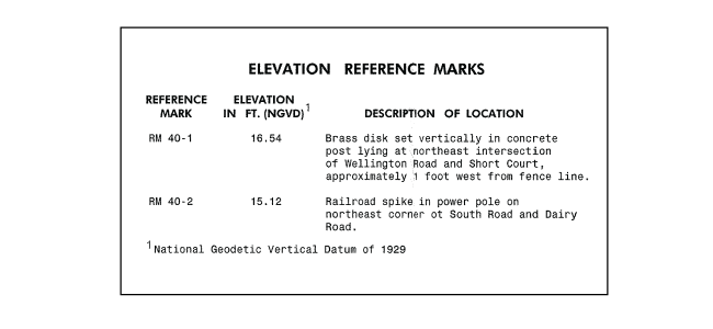
Elevation Reference Marks (ERMs) identify points where a ground elevation was established by survey. These elevations are usually expressed in feet; elevations in Puerto Rico are expressed in meters. Descriptions of the marks, including their elevations, are provided.

Scroll down to see slideshow captions.

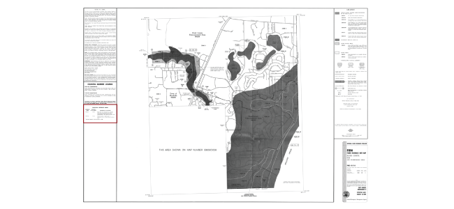
Elevation Reference Mark description on flood map
Flood map with elevation reference notes highlighted.
Elevation Reference Mark description example text
Elevation Reference Marks,  Reference mark RM 40-1 Elevation in Ft. (NGVD) Descripton of location: Brass disk set vertically in concrete post ling at northeast intersection of Wellington Road and Short Court, approximately 1 foot west from fence line. Refrence Mart FM 40-2 Elevation in Ft. (NGVD) Description of Location: Railroad spike in power pole on northeast corner of South Road and Dairy Road. (NGVD) National Geodetic Vertical Datum of 1929
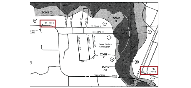
Elevation Reference Marks RM 40-1 and RM 40-2 on flood map
Elevation reference mark RM 40-1 and elevation reference mark 40-2 are highlighted on flood map
Elevation Reference Marks (ERMs) Flood Map Locations

The descriptions of the ERM locations appear in different places, depending on the format of the flood map, as seen in the table below.

Marks included on many FIRMs are temporary in nature and may not be recoverable. To obtain current elevation, description, and/or location information for other bench marks for the FIRM, you can use the National Geodetic Survey Data Explorer available at https://www.ngs.noaa.gov/NGSDataExplorer/ or you may contact the Information Service Branch of the National Geodetic Survey at http://www.ngs.noaa.gov or by telephone at 301-713-3242.

Flood Map FormatElevation Reference Mark Location
Flood Hazard Boundary MapOn last Panel(s) of the Flood Map
Older Flood Insurance Rate Map On Panel where mark appears
Newer Flood Insurance Rate MapOn Panel where mark appears and/or in FIS
Elements that May Be Found Only on Some FBFM/FIRM Panels

Panel elements that may be found only on some FBFM/FIRM Panels include:

  • Alpha-numeric Grid

Elements that will be found on FBFM panels, but not FIRM panels, in the pre-1986 FIRM/FBFM map sets include:

  • Cross Section Symbol
  • Floodway Boundaries
  • Floodway Designation
Elements Found Only on Some FBFM/FIRM Panels: Alpha-numeric Grid

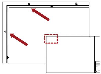
The Alpha-numeric Grid is the basis of the coordinate systems established for the Floodprone Street Index.

Alpha-numeric grid. 1 on the left vertical line and A and B on the top horizontal line. The area defined by 1-A is highlighted.
Elements Found Only on Some FBFM/FIRM Panels: Cross Section Symbol

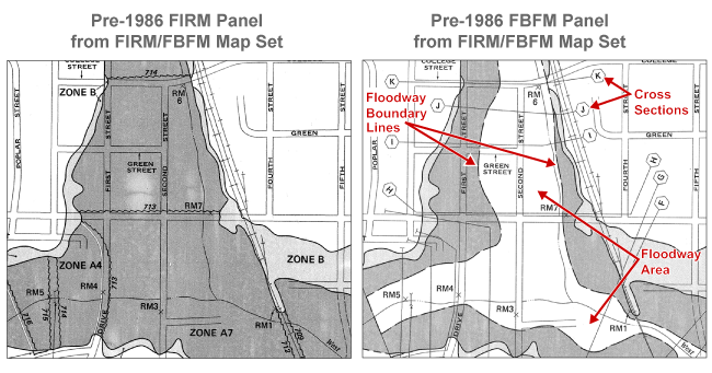
These elements will be found only on FBFM panels in the pre-1986 FIRM/FBFM map sets. They are not on the Pre-1986 FIRMs.

  • Floodway Boundary Lines
  • Cross Section Symbols
  • Floodway Area Designation

The floodway is the channel of a river or other watercourse, plus any adjacent floodplain areas that are reserved, so that the 1-percent annual chance flood discharge can be conveyed without increasing the elevation of the 1-percent annual chance flood more than a designated height.

Pre-1986 FIRM and mirror FBFM with Floodway Boundary Line, Cross Section Symbols, and Floodway area identified.
Elements Found Only on Some FBFM/FIRM Panels for Individual Communities

Elements found only on some FBFM/FIRM Panels include:

  • Community Panel Number
  • Initial Identification Date
  • Flood Hazard Boundary Map (FHBM) Revisions Chronology
  • Map Effective Date

Each element will be discussed in further detail on the following screens.

Elements Found Only on Some FBFM/FIRM Panels for Individual Communities: Community Panel Number

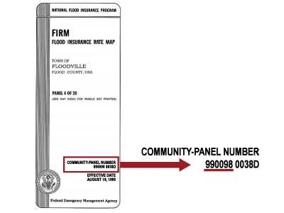
The Community Panel Number identifies the community with the first six digits and the Panel with the last five.

It corresponds to a community Panel number shown on the Index.

On the FIRM, the letter suffix following the panel number indicates the number of times the map panel has been reissued. The number 0038D in the example indicates that panel #0038 has been issued 4 times.

FIRM Flood Insurance Rate Map, Town of Floodville, Flood County, USA, Panel 4 of 26, Community Panel Number 990090 (underlined) 0038X
Note Icon
Note
Panels in a community can be updated at different times.
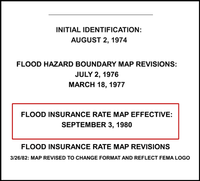
Elements Found Only on Some FBFM/FIRM Panels for Individual Communities: Initial Identification Date

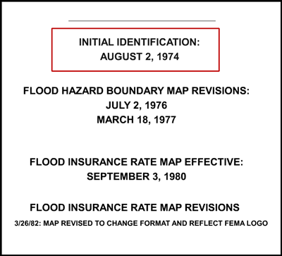
This date appears in the legend and indicates when the flood hazards in the mapped community were first identified.

Initial Identification: August 2, 1974 highlighted. Flood Hazard Boundary Map Revisions: July 2, 1976, March 18, 1977. Flood Insurance Rate Map Effective: September 2, 1980. Flood Insurance Rate Map Revisions 3/26/82: Map revised to change format and reflect FEMA LOGO
Elements Found Only on Some FBFM/FIRM Panels for Individual Communities: FHBM Revisions Chronology

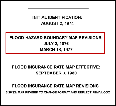
Flood Hazard Boundary Map (FHBM) Revisions Chronology lists the dates of revised versions of the Flood Hazard Boundary Map (FHBM) for the community.

When the FHBM is updated, it is typically converted to a FIRM format.

Initial Identification: August 2, 1974. Highlight begins. Flood Hazard Boundary Map Revisions: July 2, 1976, March 18, 1977.Highlight ends. Flood Insurance Rate Map Effective: September 2, 1980. Flood Insurance Rate Map Revisions 3/26/82: Map revised to change format and reflect FEMA LOGO
Elements Found Only on Some FBFM/FIRM Panels for Individual Communities: Map Effective Date

The Map Effective Date appears in the legend. It indicates when that specific Flood Map panel became effective.

Initial Identification: August 2, 1974. Flood Hazard Boundary Map Revisions: July 2, 1976, March 18, 1977.  Highlight begins. Flood Insurance Rate Map Effective: September 2, 1980. Highlight ends. Flood Insurance Rate Map Revisions 3/26/82: Map revised to change format and reflect FEMA LOGO
Elements Found Only on Countywide Panels

Elements found only on Countywide Panels include:

  • Effective Date on Countywide Map
  • Map Number

Each element will be discussed in further detail on the following screens.

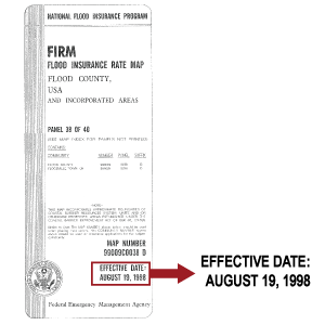
Elements Found Only on Countywide Panels: Effective Date on Countywide Map

This is the date on which the Countywide Flood Map first became effective.

Flood Maps may have been in effect for one or more of the individual communities in the county before the countywide Flood Map was published.

FIRM Flood County, USA and Incorporated Areas, Panel 38 of 40 , Effective Date: August 19, 1998
Elements Found Only on Countywide Panels: Map Number

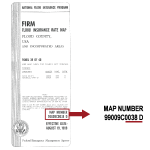
This number identifies the Panel.

It is composed of a five-digit code that identifies the county; a letter "C" that indicates countywide mapping; and a four-digit number corresponding to the Panel number followed by a letter suffix that indicates the number of times a Panel has been revised.

FIRM Flood County, USA and Incorporated Areas, Panel 38 of 40. Map Number 99009C0038 D
Lesson 4 Summary

You have just completed Lesson 4, which:

  • Demonstrated the steps to read a Map Panel
  • Described the elements found on most Map Panels
    • Floodplain Boundaries
    • Hazard Area Designation
    • Base Flood Elevation
    • Flood Zone Division Line
    • Flood Insurance Risk Zone Designations
    • North Arrow
    • Stream Lines
    • Coastal Barrier Symbol
    • Area Not Included Label
    • Map Scale
    • Panel Number
    • Notes to User
    • Elevation Reference Marks (ERMs)
  • Identified elements specific to Flood Boundary and Floodway Map (FBFM) and Flood Insurance Rate Map (FIRM) Map Panels
    • Alpha-numeric Grid
    • Cross Section Symbol
    • Floodway Boundaries
    • Floodway Designation
  • Identified elements Found Only on Some FBFM/FIRM Panels for Individual Communities:
    • Initial Identification Date
    • FHBM Revisions Chronology
    • Map Effective Date
  • Identified elements Found Only on Countywide Panels
    • Effective Date of Countywide Map Panel
    • Map Number